72 Days in the Amazon Delta, Captured in a Single Satellite Image
In a new radar image from the European Space Agency, red, green and blue mark changes across the Amazon Delta. Three Sentinel-1 observations track variations in the landscape near Macapá, Brazil, from August to October 2026.
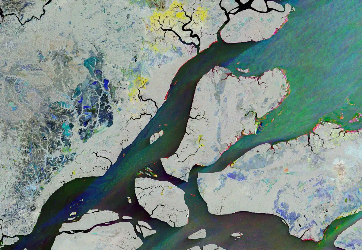
The gray area in the lower left of the image is Macapá, a Brazilian city on the equator and home to roughly half a million people. Beyond the city, red bands trace the riverbanks, patches of blue interrupt the surrounding forest, and geometric patterns mark agricultural land. None of these colors represent the landscape as it would appear to the human eye from space.
Released by the European Space Agency (ESA) on November 13, 2026, the image combines radar data collected by Copernicus Sentinel-1 on three separate dates. Blue indicates changes detected on August 15, green on September 20, and red on October 26. Areas rendered in black, white and gray showed little or no variation in radar measurements over this period.
Beyond the Clouds
Conventional optical satellites record sunlight reflected from Earth's surface. Sentinel-1, by contrast, uses a technology known as synthetic aperture radar (SAR). The satellite sends microwave signals toward Earth and measures the portion that scatters back to its instrument. Surface roughness, moisture content and physical structure all influence the returning signal.
This method is particularly useful in tropical regions such as the Amazon. Radar can operate independently of sunlight and penetrate cloud cover, allowing satellites to observe the same landscape at different times and detect changes that conventional optical instruments might miss.
A Geography in Constant Motion
Along the riverbanks north of Macapá and around the islands of the delta, concentrations of red suggest possible changes in the shape of the shoreline in October. Tiny colored blocks scattered across the river mark the presence of boats on different dates.
The sediment carried by the Amazon continually reshapes the geography of the Atlantic coast. A 2025 study published in Remote Sensing of Environment, drawing on satellite-based gravity measurements, estimated that approximately 1.3 billion metric tons of sediment accumulated annually on the Amazon's continental shelf between 2002 and 2023.
Further inland from Macapá, the colored patches may reflect natural changes in vegetation or the cycles of agricultural growth and harvesting.
A change in the radar signal, however, is not enough to establish its cause. Nor does the absence of color in forested areas mean that the forest itself has remained entirely unchanged. Many ecological processes occur beyond the detection capabilities of radar.
The image documents neither the Amazon as a whole nor a single environmental event. It records differences across a small part of the vast landscape through which the river reaches the Atlantic, observed on three dates spanning just 72 days.
— Related Reading: What a Rainforest Bird Teaches Us About the Spaces Between Worlds